Following extensive consultation with residents and stakeholders, planning applications have been submitted which will create a cycle and active travel connection from the new development at Waterbeach, over the A10 and connecting to the Science Park, Cambridge Regional College, and onward connections across the City.
Urban&Civic has been working with Cambridgeshire County Council, local partners and local communities to design both a bridge crossing supporting cyclists, pedestrians and equestrians, and a 6.5km restricted byway that will start north of Denny End Road, cross to Landbeach via a new section of cycle route, and then connect with existing Rights of Way at Akeman Street and Mere Way. The work will see these routes upgraded to enable greater use by cyclists – along with those using wheelchairs and pushchairs – while still retaining a grass route for equestrians and others to use.
An extensive consultation has been carried out over recent months, which has included walks with key landowners, webinars and workshops with local communities and user groups, and an online consultation for local communities to help shape the plans. While the route was originally conceived as a cycle commuter route to access key employment centres in the north of Cambridge, the design has been evolved to ensure it also continues to provide local leisure opportunities for neighbouring communities.
Caroline Foster from Urban&Civic, said: “We are really grateful to everyone who took the time to share their thoughts and ideas with us to ensure this significant investment really brings as many benefits as possible to local people, as well as delivers a really important piece of infrastructure which will help people make positive choices to leave their cars at home. All the feedback has made sure we can deliver the best possible solutions for existing and future residents.
“Our biggest challenge was to pull together the requirements and aspirations across different user groups and make sure we had the right designs, connections, delivery and maintenance in place – not just now but in the long term – for cyclists, walkers, horse riders, leisure-users and commuters.
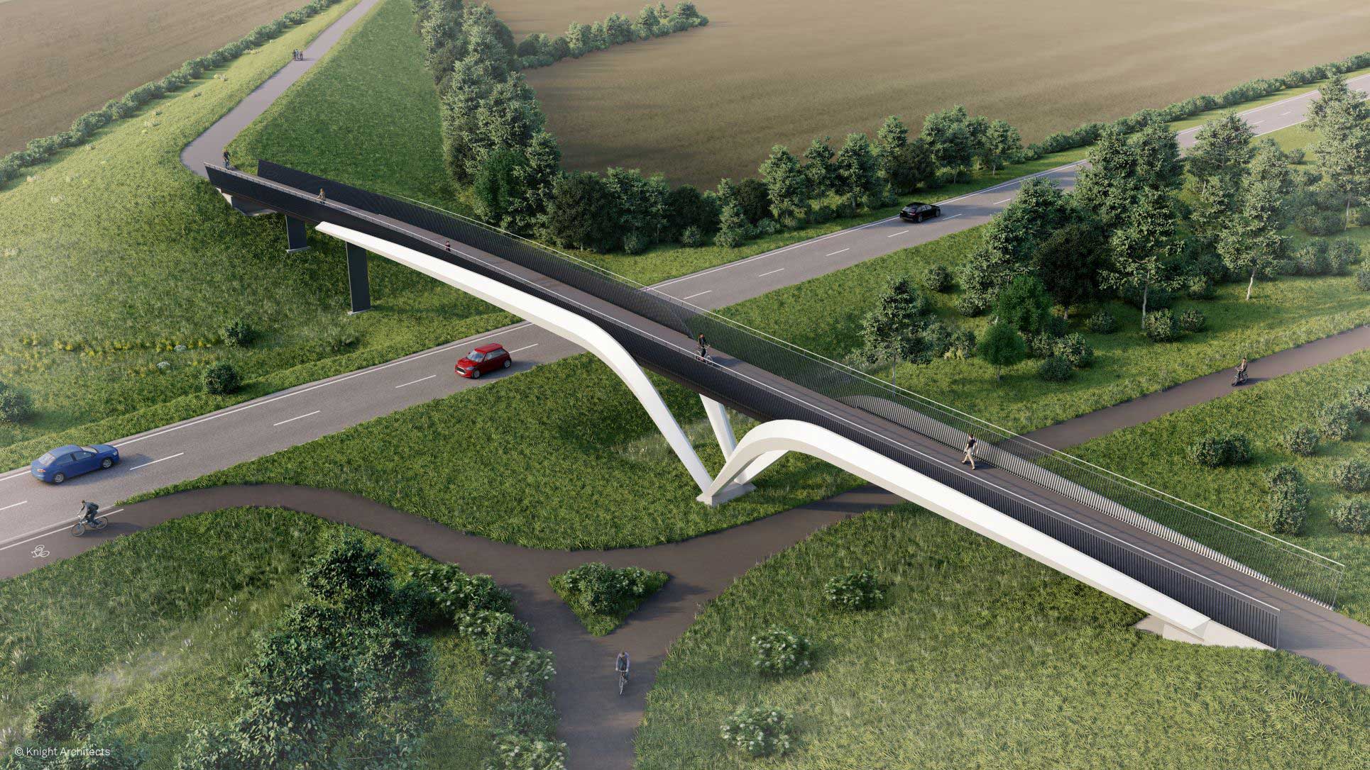
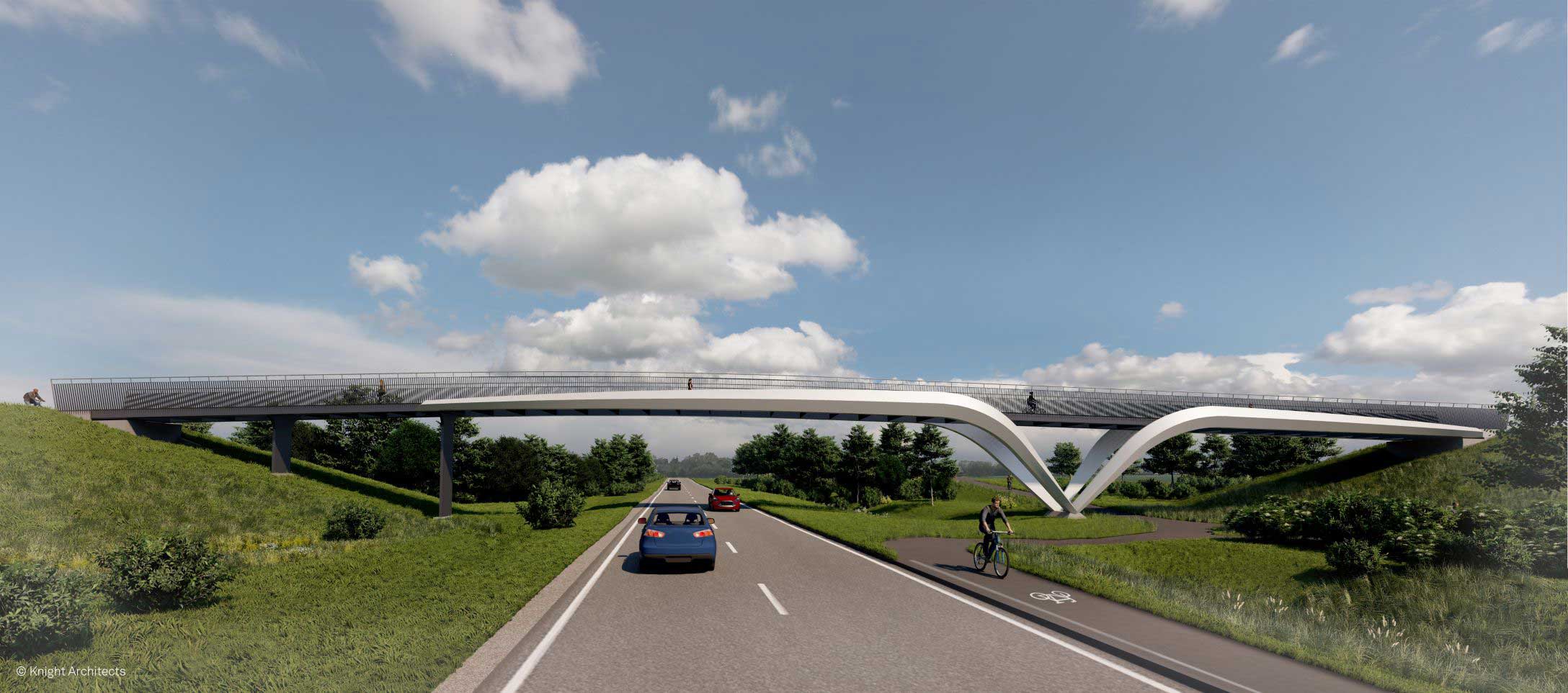
“We have worked exceptionally hard with partners to ensure the bridge across the A10 achieves all of the functions it needs to, but also provides a handsome structure at the gateway of the development. The bridge has been designed to enhance the unique landscape of the area and capture some of the aviation heritage and avian influences of Waterbeach.”
The main evolution of the design, through the consultation includes:
- Ensuring the A10 bridge is future-proofed and able to accommodate the future options for the A10 improvement works. This has involved extensive discussions with the Combined Authority, Greater Cambridge Partnership and County and District Council.
- Responding to local equestrian and bridleway groups about ensuring the route retains its grass surface, in line with best practice for “Active Travel Routes”. This ensures a 2m grass track along the full route. This will run alongside the Heritage Surface Course that will be installed on the 3m hard surface route, and provide a 5-6m wide route along the full length of the route to ensure capacity and surface options for all users.
- Heritage Surface course will be used to provide a softer colour and finish for the harder surface area along the route. This is in line with the long term management standards of the County Council, who will ultimately adopt and manage the route, as it is public highway.
- The design of the A10 bridge has also been adapted so equestrians can dismount and safely lead their horses across the bridge, with mounting blocks, waiting zones and warning sign, a new noise attenuating surface and higher parapets to prevent horses being frightened by the traffic.
- Working with local farmers to ensure passing bays enable the safe movement of both heavy agricultural vehicles and fruit farm operations at key pinch points along the route.
- Ensuring safe and lit crossing at the Butt Lane junction.
The route has also been designed to minimise impact on the environment along this historic route, working around trees and hedgerows where possible while still achieving the widths required to accommodate the full range of users; and being delivered in a way that protects the historic route of the Roman Road.
The route will not only connect safely to the major and growing employment centre of the Cambridge Science Park, but also to employment and learning at Cambridge Regional College. It will allow onward connection into the National Cycle Network 51 (Busway to St Ives) and the Chisolm Trail at Cambridge North, which will pass through the heart of the city and connect to the Cambridge Biomedical Campus to the south. The route will increase the opportunity for people from Histon, Impington, Landbeach and Cottenham to cycle to the Science Park, Cambridge Research College and other locations in the north of the city and will also provide a pleasant leisure route out of Cambridge into the countryside. As the Waterbeach Greenway route is delivered, it will also provide a circular cycle loop between Waterbeach and the City.
Caroline added: “This is a really exciting piece of cycle investment which provides an opportunity to give the north of the City the same safe cycle connectivity as the south. It is a key part of the new development’s investment in sustainable travel for new residents and our neighbours.
“As a new development, Waterbeach is working hard to deliver a shift in the way people think, work and move about, and we are committed to moving people away from car use to regular cycle commuting. We will continue to work with local cycle groups and local communities, putting infrastructure in place from day one for our first residents moving in and creating the right information, incentives and culture to ensure Waterbeach provides a truly sustainable way of living.”
Some of the key elements of the Route will be delivered through different planning mechanisms, as set out below with the main features of the applications:
A10 Bridge: the design aims to ensure the bridge provides a positive landmark within the wider landscape and will connect the new footpaths and cycleways inside the development – as well as foot, cycle and bridleways in Waterbeach – with Mere Way on the other side of the A10. This has been designed to cover both the existing span of the A10 and a dualled A10 if this comes forward on the existing route in the future. This is being bought forward as part of both the Full Planning Application and Reserved Matters Applications which address key aspects of design around the on site area and connections where the bridge “lands”.
New Cycle connection from the A10 bridge to connect to Green End, Landbeach, following historic field boundaries. This will come forward as a Full Planning Application, and therefore will be featured on the South Cambs Planning Register and be subject to a 21 day consultation.
Cycle route through Landbeach, following Green End, Spaldings Lane and Cockfen Road will be delivered under a Section 278 agreement with Cambridgeshire County Council as it is existing Public Highway. This is not formally consulted on by the Authorities post-submission, as it is not part of the planning process, but changes to the existing Highway. That is partly why we did such extensive consultation prior to submission.
Akeman Street and Mere Way: upgrading the existing byway, which runs from Landbeach, crosses Butt Lane and goes under the A14 to connect to Cambridge Science Park and Cambridge Regional College. This Will be delivered under a Section 278 agreement with Cambridgeshire County Council. This is not formally consulted on by the Authorities post-submission, as it is not part of the planning process, but changes to the existing Highway. That is why we did such extensive consultation prior to submission.
We are really grateful to everyone who took the time to share their thoughts and ideas with us to ensure this significant investment really brings as many benefits as possible to local people.
